| __ | Surveyor program Landing Site | __ |
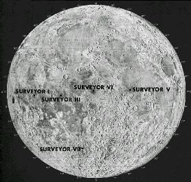
Landing site Map
| Surveyor 1 Landing Site : | Oceanus Procellarum | Latitude 2.45 deg S, Longitude 43.22 deg W |
| Surveyor 2 Landing Site : | Southeast of Copernicus Crater (失敗/激突) | - |
| Surveyor 3 Landing Site : | Oceanus Procellarum (Ocean of Storms) | Latitude 2.94 S, Longitude 336.66 E |
| Surveyor 4 Landing Site : | (失敗/激突) | - |
| Surveyor 5 Landing Site : | Mare Tranquillitatus (Sea of Tranquility) | Latitude 1.41 N, Longitude 23.18 E |
| Surveyor 6 Landing Site : | Sinus Medii | Latitude 0.46 N, Longitude 358.63 E |
| Surveyor 7 Landing Site : | Tycho North Rim | Latitude 41.01 S, Longitude 348.59 E |
![]()
![]()
![]()
End of Surveyor program Landing Site
![]()